|
|
 |
 |
|
Favorite
Links |
 |
Add Your
Map Link |  |
|
 |
|

|  |
21 - 40 of 46 |
|
|
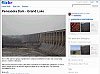
| Pensacola Dam - Grand Lake on Flickr - gdsanders
This is the start of a group of photos from a trip last weekend to Tulsa and surrounding areas in eastern Oklahoma. Pensacola Dam forms Grand Lake of the Cherokees in northeastern Oklahoma, is over a mile in length and is the world's largest multiple-arch concrete dam. The dam was completed in 1938. |
| |
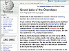
| Wikipedia - Grand Lake O' the Cherokees
It was created in 1940, having originally been planned prior to statehood as a source for hydroelectric power for the Cherokee Nation. Whilst an electric utility company was incorporated, the lake was not actually constructed until 1938, when construction of Pensacola Dam on the Grand River began as a Works Progress Administration project. The dam was completed in 1940, creating the lake behind it. |
| |
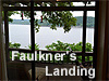
| FAULKNER'S LANDING
Faulkner's Landing consists of a 1,680 square foot home on 1.3 private acres located atop a beautiful bluff overlooking pristine Horse Creek Cove on Grand Lake. The cove,which feels like a private oasis,is large enough and deep enough for all boating activities. The private dock is complete with a boat lift,3 Sea Doo slips as well as a swim dock. This lakefront home sits atop a beautiful bluff on Horse Creek. |
| |
| Complete Photographic Magic LLC
Our studio goal is to provide a functional as well as an emotionally pleasing photographic experience that results in visual memories for generations to come. |
| |
| AirNav: 3O9 - Grand Lake Regional Airport
Complete aeronautical information about Grand Lake Regional Airport (Afton OK USA) Monkey Island including location runways taxiways navaids radio frequencies FBO information fuel prices sunrise and sunset times aerial photo airport diagram. 918 257-8602 |
| |
| Cowen Construction
Cowen offers construction services ranging from the conceptual idea and plan stage completely through the finished project and post construction. We specialize in Healthcare, Industrial, Retail, Commercial, and High End Residential. Our goal is to not only meet, but exceed our client's construction expectations. Commercial and Residential Contracting in Oklahoma for over 100 years. |
| |
| ProBass Networks: The Complete Bass Fishing
ProBass Fishing, The Complete Professional Bass Fishermans resource. Featuring Lake reports, Free Boat Ads, Live Chat, Message boards, links and more |
| |
| The Village at St. Andrews
The Village at St. Andrews project is a first for Grove inasmuch as all facilities promised are in place prior to construction of the units. All streets, curbs and gutters, utilities, phone and cable |
| |
| Search Engine Optimization Articles - Website Promotion - SEO News - Complete Webmaster's Reference
A comprehensive and categorized collection of articles, news and software reviews on search engine optimization, SE marketing, and web promotion |
| |
| The Bravo Shop
Your Source for Bmax Bravo & Mercury Marine Outdrive Parts - Bmax Complete Units Bmax Upper Parts Bmax Lower Parts Bmax Accessories Pre-owned Inventory Bravo XR Upper Bravo XR Lower Bravo 1 Upper Bravo 1 Lower Bravo 1 Universal Bravo XR Universal Special tools Bravo HP Shafts Imco Shafts Gear Lube NEO Engine oils Apparel Water Pumps Bmax,Bravo,Mercruiser,Outdrive,Outdrive Parts,Mercury Marine,TRS,SSM,Bam Marine |
| |
| Grand Escape Room
What is an Escape Room? An escape room is a physical adventure game in which players solve a series of puzzles and riddles using clues, hints, and strategies to complete the objectives at hand. Players are given a set time limit to unveil the secret plot which is hidden within the rooms. Grand Escape Room 311 S Grand St. Grove 918-791-3344 |
| |
| Miami Regional Airport - KMIO
Complete aeronautical information about Miami Regional Airport (Miami OK) and an airport diagram. |
| |
| Monkey Island Trail
Walk, run or bike the Monkey Island Trail. Phase I, II and III are now completed. Phase IV to Tera Miranda is in the planning stage. |
| |
| AirNav: KMIO - Miami Municipal Airport
Complete aeronautical information about Miami Municipal Airport Miami, OK, USA, including location, runways, taxiways, navaids, radio frequencies, FBO information, fuel prices, hotel and motel listings, hotels, weather, sunrise and sunset times, aerial photo, airport diagram. |
| |
| AirNav: H04 - Vinita Municipal Airport
Complete aeronautical information about Vinita Municipal Airport Vinita, OK, USA, including location, runways, taxiways, navaids, radio frequencies, FBO information, fuel prices, hotel and motel listings, hotels, weather, sunrise and sunset times, aerial photo, airport diagram. |
| |
| AirNav: KGMJ - Grove Municipal Airport
Complete aeronautical information about Grove Municipal Airport Grove, OK, USA, including location, runways, taxiways, navaids, radio frequencies, FBO information, fuel prices, hotel and motel listings, hotels, weather, sunrise and sunset times, aerial photo, airport diagram. |
| |
| Ottawa Co. Roadmaps
A 1937 road map that was distributed at Gulf gasoline stations along Route 66 and other roads show the Tri-State lead and zinc mining district as it looked then. Many of these small villages are completely gone now. Route 66 divides Ottawa County in half by entering just south of Baxter Springs, Kansas, and leaving just south of Afton. |
| |
| AirNav: 4O6 - Cherokee Seaplane Base
Complete aeronautical information about Cherokee Seaplane Base (Afton, OK, USA), including location, runways, taxiways, navaids, radio frequencies, FBO information, fuel prices, sunrise and sunset times, aerial photo, airport diagram. |
| |
| AirNav: OK30 - Grandcraft Landing Strip Airport
Complete aeronautical information about Grandcraft Landing Strip Airport (Langley, OK, USA), including location, runways, taxiways, navaids, radio frequencies, FBO information, fuel prices, sunrise and sunset times, aerial photo, airport diagram. |
| |
| AirNav: OK95 - Disney Airport
Complete aeronautical information about Disney Airport (Disney, OK, USA), including location, runways, taxiways, navaids, radio frequencies, FBO information, fuel prices, sunrise and sunset times, aerial photo, airport diagram. |
|
| | | |