|
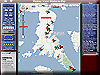
| Monkey Island Map
Map for Monkey Island. Business Locations, Restaurants, Clubs, Lodging, and the fun in the sun! And a little history for your information. User Photo Uploads. Monkey Island History, Facts and Details ... |
|
|
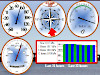
| Grand Lake Oklahoma Weather Station
Current Conditions including Weather Radar, Current Lake Level, Water Temperature, Reservoir Release, Precipitation, Humidity, Wind, Pool Elevation, Weather Maps, Temperature History, NexRad, Solar Maps, Space Weather and More ... |
|
|
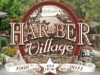
| Har-Ber Village
One of the largest antique museums in the United States, located on the shores of Grand Lake O' The Cherokees in Grove, Oklahoma. Built as a gift to the public from Harvey and Bernice Jones, Har-Ber Village is a reconstructed turn-of-the century village of over one hundred buildings and collections. Have your wedding at Har-Ber Village's vintage wedding venue. :) Shop & Dine Blue Cat Bistro |
|
|
| Ottawa County, Oklahoma. Photographs From Yesteryear.
Vintage photographic views of Ottawa County, Oklahoma. |
|
|
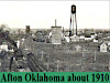
| Views of Afton, Oklahoma in 1910
Afton, Oklahoma in 1910 |
|
|
| Commerce, Oklahoma
One of Ottawa County's Earliest Mining Towns. This view of Commerce Oklahoma was taken about 1917 and is looking west down Commerce Ave. |
|
|
| Early Pictures of Wyandotte, Oklahoma
Main street of Wyandotte, Oklahoma during the horse and buggy days |
|
|
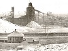
| Picher, Oklahoma in 1919
oklahoma counties state of oklahoma miami, oklahoma ottawa county oklahoma mining ottawa county, oklahoma mining district picher oklahoma zinc ottawa co |
|
|
| Douthat, Oklahoma
Douthat, Oklahoma An Early Ottawa County Mining Town. |
|
|
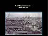
| Early Photos of Cardin, Oklahoma
Pictures of Cardin, Oklahoma, an early mining town in Ottawa County. |
|
|
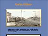
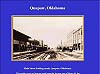
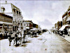
| Main street of Quapaw
This muddy street at Quapaw would someday become part of Route 66, but in this photo, taken about 1920, is anything but America's most famous highway. |
|
|
| Early Day Photos of Miami, Oklahoma
This picture was taken in 1895 and shows the east side of Main St. from Central south to First. Two story building in upper right was a hotel and can be seen again in a later picture. |
|
|
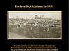
| Boom Town Days At Hockerville, Oklahoma
Hockerville, Oklahoma was an early mining town in Ottawa County. Photo 1918 |
|
|
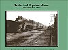
| Railroads in Ottawa County, Ok.
Views of trains and Frisco depot at Miami, Ok. |
|
|
| Vinita Daily Journal
Daily updated News, Sports, Vinita Oklahoma, Past, Birth, Weddings, Calendar, Anniversay, Guest book Archives, Evrything you want to know in Vinita Oklahoma |
|
|
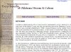
| DISNEY - Encyclopedia of Oklahoma History & Culture
Disney is located in northeastern Mayes County on the east end of Pensacola Dam on State Highway 28. The mile-long highway across the dam separates the city of Langley from Disney. Both towns have similar histories, beginning with the 1935 construction of the Grand Lake dam. |
|
|
| KETCHUM - Encyclopedia of Oklahoma History & Culture
Located on State Highway 85 in Craig County's southeastern corner, Ketchum is one mile north of the Mayes County line and one-half mile west of the Delaware County line. Ketchum was originally established in 1899 in present Mayes County, slightly more than a mile south-southwest of its present location, on the banks of Grand River along a wagon trail. |
|
|
| B&D Precision Fence
We are a locally owned business in Grove, OK. We have a history of building Quality Precise' Fences for 10 years and counting. Let us serve all of your fencing needs! Call Us TODAY For Your FREE Estimate! 918-791-1744 Fully Insured Locally Owned and Operated |
|
|
| Official Site of the Cherokee Nation based in Tahlequah Oklahoma - Federally Recognized
Cherokee - The Official Web Site of the Cherokee Nation based in Tahlequah Oklahoma. The Western Band of Cherokee are a federally recognized Native American Indian Tribe. This web site containd Cherokee Nation News, services for tribal members, information regarding the Cherokee, Culture, History plus much more. |
|
|
| Grand Lake & Monkey Island Information and Real Estate
Grand Lake and Monkey Island Community Info, Fun Stuff homes for sale, Search the MLS |
|