


| Sunrise 0628 Sunset 2020 |


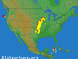
| Sunrise 06:28 Sunset 20:20
Today: Sunny. Highs in the lower 90s. Southeast winds around 5 mph. Tonight: Clear. Lows around 70. Southeast winds around 5 mph. . Tuesday Sunny. Highs in the mid 90s. South winds 5 to 10 mph. .TUESDAY NIGHT...Mostly clear in the evening, then becoming partly cloudy. Lows in the mid 70s. Southeast winds around 5 mph. . Wednesday Sunny. Highs in the mid 90s. South winds 5 to 10 mph. Heat index values up to 104. .WEDNESDAY NIGHT...Partly cloudy in the evening, then becoming mostly cloudy. Lows in the mid 70s. . Thursday Mostly sunny. A chance of showers and thunderstorms in the afternoon. Highs in the mid 90s. Chance of rain 30 percent. Heat index values up to 105. .THURSDAY NIGHT...Mostly cloudy. A chance of showers and thunderstorms in the evening, then showers likely with a slight chance of thunderstorms after midnight. Lows in the lower 70s. Chance of rain 60 percent. . Friday Mostly sunny with a chance of showers and thunderstorms. Highs in the lower 90s. Chance of rain 50 percent. .FRIDAY NIGHT...Partly cloudy with a slight chance of showers and thunderstorms. Lows in the lower 70s. Chance of rain 20 percent. . Saturday Mostly sunny with a slight chance of showers and thunderstorms. Highs in the lower 90s. Chance of rain 20 percent. Heat index values up to 100. .SATURDAY NIGHT...Mostly clear. Lows in the lower 70s. . Sunday Sunny. Highs in the lower 90s. Heat index values up to 105. OKZ069-032200- 1785755425 6:50:37 |


